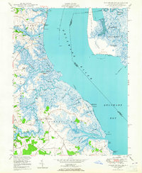
1948 Map of Taylors Bridge
USGS Topo · Published 1965About this map
Taylors Bridge sits at the heart of this coastal landscape, where the tides of the Delaware River meet an intricate network of marshes and tidal guts. Mapped in the late 1940s, the region is defined by its deep maritime and agricultural heritage, visible in the land-management patterns of Vance Neck and Deakyne Neck. The waterway infrastructure is remarkably detailed, showing the drainage systems of Sawmill Ditch, Big Ditch, and Rays Ditch that carved the lowlands into productive districts.
Find a feature on this map
64 named features on this map. Tap any name to fly to it.
Don’t see what you’re looking for? This feature index may not catch every label — zoom into the map to look around manually.
Map Details
Editions of this 1948 Taylors Bridge Map
3 editions found
Other maps of this area

1890 · Salem
USGS Topo · 1:62,500

1890 · Bay Side
USGS Topo · 1:62,500

1894 · Bay Side
USGS Topo · 1:62,500

1898 · Salem
USGS Topo · 1:62,500

1899 · Vineland
USGS Topo · 1:125,000

1899 · Dover
USGS Topo · 1:125,000

1901 · Camden
USGS Topo · 1:125,000

1904 · Wilmington
USGS Topo · 1:62,500

1906 · Dover
USGS Topo · 1:125,000

1906 · Wilmington
USGS Topo · 1:62,500
Featured Places
- Lower Alloways Creek Township, NJ
- Fennimore Landing, DE
- Elsinboro Township, NJ
- Stave Landing, DE
- The Island, DE