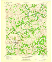
1960 Map of Taylorsville
USGS Topo · Published 1960About this map
Taylorsville sits at the significant confluence of the Salt River and Brashears Creek, serving as the primary hub of this 1960 Kentucky landscape. The geography is defined by deep, sinuous river bends and a network of named drainages like Guist Creek and Possum Creek that carve through the high ground of Anderson Hill and Beech Ridge. This era shows a rural Spencer County transition, where small agricultural communities such as Normandy, Rivals, and Veech are connected by a developing road network that follows the meandering watercourses. Genealogists can find several local burial sites including Little Mount Cem and Valley Cem, while industrial activity is noted at a Quarry south of the main town. The winding course of Little River and the prominent Snyder Bluff further illustrate the complex terrain that dictated the placement of early settlements and farms in the valley.
Find a feature on this map
27 named features on this map. Tap any name to fly to it.
Don’t see what you’re looking for? This feature index may not catch every label — zoom into the map to look around manually.
Map Details
Editions of this 1960 Taylorsville Map
3 editions found
Other maps of this area

1923 · Waddy
USGS Topo · 1:48,000

1925 · Mount Eden
USGS Topo · 1:48,000

1927 · Mount Eden
USGS Topo · 1:62,500

1929 · Taylorsville
USGS Topo · 1:62,500

1951 · Fisherville
USGS Topo · 1:24,000

1951 · Waterford
USGS Topo · 1:24,000

1952 · Chaplin
USGS Topo · 1:24,000

1953 · Bloomfield
USGS Topo · 1:24,000

1953 · Fairfield
USGS Topo · 1:24,000

1954 · Taylorsville
USGS Topo · 1:24,000