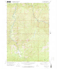
1973 Map of Teapot Mtn
USGS Topo · Published 1977About this map
The South Fork Salmon River and its major tributaries, including the East Fork South Fork Salmon River, carve through this section of the Payette National Forest in Valley County. The 1973 survey reveals a landscape organized around river access and forest management, anchored by the Krassel Ranger Sta and the remote Reed Ranch. A network of pack trails, such as the Miners Peak Trail and the Cougar Ridge Trail, provides the primary means of traversing the high ridges like Indian Ridge and Rainbow Ridge. This era of backcountry infrastructure is well-documented through the numerous recreation sites along the water, including Deadman Campground and Teepee Creek Campground, as well as the Reed Ranch Landing Strip which served as a critical aviation link for this isolated terrain.
Find a feature on this map
52 named features on this map. Tap any name to fly to it.
Don’t see what you’re looking for? This feature index may not catch every label — zoom into the map to look around manually.
Map Details
Editions of this 1973 Teapot Mtn Map
2 editions found
Other maps of this area

1956 · Elk City
USGS Topo · 1:250,000

1957 · Challis
USGS Topo · 1:250,000

1960 · Elk City
USGS Topo · 1:250,000

1960 · Challis
USGS Topo · 1:250,000

1963 · Challis
USGS Topo · 1:250,000

1969 · Enos Lake
USGS Topo · 1:24,000

1969 · Parks Peak
USGS Topo · 1:24,000

1969 · Williams Peak
USGS Topo · 1:24,000

1973 · Blackmare
USGS Topo · 1:24,000

1973 · White Rock Peak
USGS Topo · 1:24,000