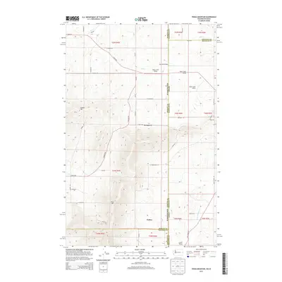
2014 Map of Tekoa Mountain
USGS Topo · Published 2014About this map
Tekoa Mtn and Gelbert Mtn dominate the high ground along the Washington and Idaho border, marking a transition from the rolling hills of the Palouse into the forested mountains of the Panhandle. This landscape is defined by the sharp North-South political boundary between Spokane Co and Whitman Co in Washington, and Kootenai Co and Benewah Co in Idaho. Small rural clusters like Stringtown and Wallner are situated among a network of gravel and local roads, illustrating the area's agricultural and timber-driven settlement patterns. The drainage of Rock Creek Valley is a central topographic feature, with Rock Cr winding through the northern sections near the Idaho Road Bridge. In the southern reaches, Lovell Valley provides a more sheltered, low-lying area where Little Hangman Cr begins its course, showing the intricate watershed connections that define this interstate borderland.
Find a feature on this map
53 named features on this map. Tap any name to fly to it.
Don’t see what you’re looking for? This feature index may not catch every label — zoom into the map to look around manually.
Map Details
Editions of this 2014 Tekoa Mountain Map
This is the sole edition of this map. No revisions or reprints were ever made.
Other maps of this area
1903 · Oakesdale
USGS Topo · 1:125,000
1905 · Oakesdale
USGS Topo · 1:125,000
1954 · Fairfield
USGS Topo · 1:62,500
1955 · Spokane
USGS Topo · 1:250,000
1957 · Plummer
USGS Topo · 1:62,500
1957 · Tensed
USGS Topo · 1:62,500
1958 · Spokane
USGS Topo · 1:250,000
1964 · Oakesdale
USGS Topo · 1:24,000
1964 · Tekoa
USGS Topo · 1:24,000
1975 · Plummer NW
USGS Topo · 1:24,000