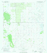
1956 Map of Telegraph Swamp NW
USGS Topo · Published 1974About this map
Telegraph Swamp dominates the western half of this Florida interior landscape, its dense woodland areas and complex hydrology meticulously recompiled from 1973 aerial photography. The map reflects a sparsely developed region of Charlotte County where the natural drainage patterns of the swamp define the environment. While human habitation is minimal, the geometric precision of the township and range lines—specifically the boundary between R. 26 E. and R. 27 E.—imposes a human grid over the water-logged terrain. This 1950s survey, updated in the 1970s, captures the land before significant modern drainage or development altered the native wetlands of the Florida peninsula.
Find a feature on this map
2 named features on this map. Tap any name to fly to it.
Don’t see what you’re looking for? This feature index may not catch every label — zoom into the map to look around manually.
Map Details
Editions of this 1956 Telegraph Swamp NW Map
2 editions found
Other maps of this area

1956 · Arcadia SE
USGS Topo · 1:24,000

1956 · Telegraph Swamp
USGS Topo · 1:24,000

1956 · Telegraph Swamp NE
USGS Topo · 1:24,000

1956 · Telegraph Swamp NW
USGS Topo · 1:24,000

1956 · Long Island Marsh SW
USGS Topo · 1:24,000

1956 · Bermont
USGS Topo · 1:24,000

1956 · West Palm Beach
USGS Topo · 1:250,000

1956 · Fort Pierce
USGS Topo · 1:250,000

1957 · West Palm Beach
USGS Topo · 1:250,000

1957 · Long Island Marsh SE
USGS Topo · 1:24,000