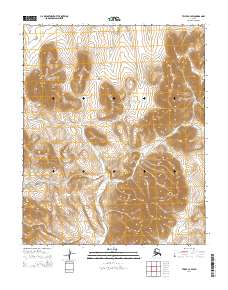
2014 Map of Teller C-4 SW
USGS Topo · Published 2014About this map
The Continental Divide defines the northern high ground of this Seward Peninsula landscape, where drainage patterns shift across the remote interior of the Nome census area. This 2014 survey captures a hydrological crossroads centered on the Don River, which winds southward through the center of the sheet. Its tributaries, including Anderson Cr and Elkington Cr, draw from the surrounding ridges, illustrating the natural water-shedding paths of the subarctic tundra. To the southeast, the terrain transitions toward the drainage of Tozer Cr and smaller feeders like Deer Br and Willow Br. The map's sparse human footprint, devoid of roads or settlements, underscores the untouched character of this region, providing a baseline for environmental study and mapping the precise alignment of the divide.
Find a feature on this map
13 named features on this map. Tap any name to fly to it.
Don’t see what you’re looking for? This feature index may not catch every label — zoom into the map to look around manually.
Map Details
Editions of this 2014 Teller C-4 SW Map
This is the sole edition of this map. No revisions or reprints were ever made.
Other maps of this area

1950 · Teller
USGS Topo · 1:250,000

1950 · Teller B-4
USGS Topo · 1:63,360

1950 · Teller C-4
USGS Topo · 1:63,360
1950 · Teller B-5
USGS Topo · 1:63,360

1950 · Teller C-5
USGS Topo · 1:63,360

1951 · Teller
USGS Topo · 1:250,000

1957 · Teller
USGS Topo · 1:250,000

1958 · Teller
USGS Topo · 1:250,000
2014 · Teller C-4 SE
USGS Topo · 1:25,000
2014 · Teller B-5 NE
USGS Topo · 1:25,000