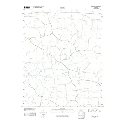
2010 Map of Temple Hill
USGS Topo · Published 2010About this map
Temple Hill and the uniquely named settlement of Eighty Eight anchor this Barren County landscape, characterized by a dense network of country roads and family-named landmarks. The topography is defined by the winding paths of Glover Creek and Falling Timber Creek, which carve through the terrain alongside numerous smaller tributaries like Elbow Spring Creek and Bailey Branch. This 2010 survey reflects a rural Kentucky environment where local heritage is preserved in numerous small burial grounds, including Peers Cemetery, Groce Cemetery, and Peden Cemetery. The northern edge of the map is traversed by the Louie B Nunn-Cumberland Parkway, representing the primary modern thoroughfare connecting these traditional farming communities. The abundance of named roads, such as Bethel Church Rd and White Chapel Rd, suggests a long-established social fabric centered around local congregations and family homesteads.
Find a feature on this map
71 named features on this map. Tap any name to fly to it.
Don’t see what you’re looking for? This feature index may not catch every label — zoom into the map to look around manually.
Map Details
Editions of this 2010 Temple Hill Map
This is the sole edition of this map. No revisions or reprints were ever made.
Other maps of this area

1935 · Horse Cave
USGS Topo · 1:48,000

1938 · Horse Cave
USGS Topo · 1:62,500

1953 · Sulphur Well
USGS Topo · 1:24,000

1953 · Tracy
USGS Topo · 1:24,000

1953 · Sulphur Lick
USGS Topo · 1:24,000

1953 · Temple Hill
USGS Topo · 1:24,000

1953 · Glasgow South
USGS Topo · 1:24,000

1953 · Freedom
USGS Topo · 1:24,000

1953 · Summer Shade
USGS Topo · 1:24,000
1954 · Glasgow North
USGS Topo · 1:24,000