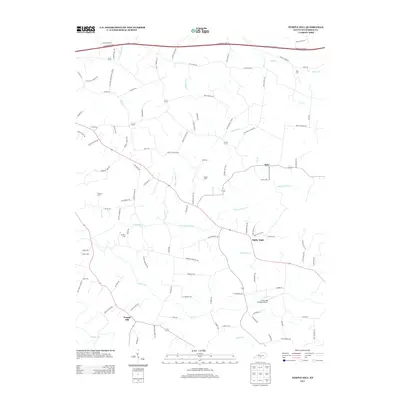
2013 Map of Temple Hill
USGS Topo · Published 2013About this map
Eighty Eight and Kino anchor this rural landscape in Barren County, where a network of small creeks like Falling Timber Cr and Glover Cr defines the drainage patterns of south-central Kentucky. The terrain is marked by a high concentration of family burial sites, including Peers Cem, Bowles Cem, and Peden Cem, which offer significant value for genealogists tracing local lineage. The road system radiates from small hubs, with Kino Eighty Eight Rd and Lecta Kino Rd connecting the scattered homesteads and farms. A notable modern addition to the pastoral setting is the Creek Side Landing Airport located near the southern reaches of the quadrangle. From the intersection at Temple Hill to the northern passage of the Cumberland Pkwy E, the map illustrates a region where tradition and modern transport corridors meet.
Find a feature on this map
107 named features on this map. Tap any name to fly to it.
Don’t see what you’re looking for? This feature index may not catch every label — zoom into the map to look around manually.
Map Details
Editions of this 2013 Temple Hill Map
This is the sole edition of this map. No revisions or reprints were ever made.
Other maps of this area

1935 · Horse Cave
USGS Topo · 1:48,000

1938 · Horse Cave
USGS Topo · 1:62,500

1953 · Sulphur Well
USGS Topo · 1:24,000

1953 · Tracy
USGS Topo · 1:24,000

1953 · Sulphur Lick
USGS Topo · 1:24,000

1953 · Temple Hill
USGS Topo · 1:24,000

1953 · Glasgow South
USGS Topo · 1:24,000

1953 · Freedom
USGS Topo · 1:24,000

1953 · Summer Shade
USGS Topo · 1:24,000
1954 · Glasgow North
USGS Topo · 1:24,000