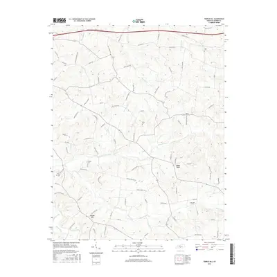
2016 Map of Temple Hill
USGS Topo · Published 2016About this map
Temple Hill and the uniquely named Eighty Eight serve as focal points for this rural Barren County landscape, characterized by a dense network of country roads and creek valleys. The terrain is deeply etched by the winding courses of Skaggs Creek and Falling Timber Creek, which gather numerous tributaries like Brushy Fork and Swannigan Cr as they flow westward. The settlement pattern remains primarily agricultural and residential, connected by routes such as Lecta Kino Rd and Bluff Springs Rd that trace the ridgelines between drainage basins. Local heritage is preserved in several family and community burial grounds, including Peers Cem in the north near Kino and Barbour Cem to the west. To the south, Creek Side Landing marks a point of access along Glover Creek, reflecting the importance of these waterways to the local geography. The northern edge of the map is defined by the high-speed corridor of the Louie B Nunn-Cumberland Parkway, contrasting with the winding local lanes like Witty Rd and Hollis Thomas Rd.
Find a feature on this map
90 named features on this map. Tap any name to fly to it.
Don’t see what you’re looking for? This feature index may not catch every label — zoom into the map to look around manually.
Map Details
Editions of this 2016 Temple Hill Map
This is the sole edition of this map. No revisions or reprints were ever made.
Other maps of this area

1935 · Horse Cave
USGS Topo · 1:48,000

1938 · Horse Cave
USGS Topo · 1:62,500

1953 · Sulphur Well
USGS Topo · 1:24,000

1953 · Tracy
USGS Topo · 1:24,000

1953 · Sulphur Lick
USGS Topo · 1:24,000

1953 · Temple Hill
USGS Topo · 1:24,000

1953 · Glasgow South
USGS Topo · 1:24,000

1953 · Freedom
USGS Topo · 1:24,000

1953 · Summer Shade
USGS Topo · 1:24,000
1954 · Glasgow North
USGS Topo · 1:24,000