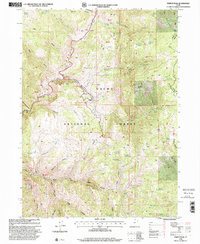
1998 Map of Temple Peak
USGS Topo · Published 2001About this map
Logan Canyon serves as the central corridor for this late-twentieth-century study of the Cache National Forest. The landscape is defined by its water resources and seasonal stock management infrastructure, featuring high-elevation points like Temple Peak and several family-named landmarks including Ephraims Grave. The drainage network is particularly dense here, with the Logan River and its various tributaries such as West Hodges Creek and Spawn Creek carving through the terrain. Evidence of the region's historical industry and land use is found at the Temple Fork Sawmill and livestock enclosures like Twin Creek Corral and Hunsaker Corral. The map also traces the Scenic Byway alongside the river, while a network of primitive routes like the Western Trail and various 4wd tracks provide access to the more secluded springs and hollows found throughout the area.
Find a feature on this map
65 named features on this map. Tap any name to fly to it.
Don’t see what you’re looking for? This feature index may not catch every label — zoom into the map to look around manually.
Map Details
Editions of this 1998 Temple Peak Map
This is the sole edition of this map. No revisions or reprints were ever made.
Other maps of this area

1912 · Randolph
USGS Topo · 1:125,000

1914 · Logan
USGS Topo · 1:125,000

1916 · Logan
USGS Topo · 1:125,000

1949 · Boulter Mts
USGS Topo · 1:24,000

1954 · Ogden
USGS Topo · 1:250,000

1958 · Ogden
USGS Topo · 1:250,000

1960 · Ogden
USGS Topo · 1:250,000
1969 · Tony Grove Creek
USGS Topo · 1:24,000

1969 · Boulder Mtn
USGS Topo · 1:24,000
1969 · Logan Peak
USGS Topo · 1:24,000