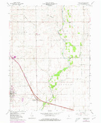
1962 Map of Templeton
USGS Topo · Published 1980About this map
Templeton and Oxford stand as the primary hubs of this Benton County landscape, where the convergence of the Norfolk and Western and Conrail lines highlights a region defined by its rail connectivity. The map captures a transition in agricultural infrastructure, evidenced by Storage Bins and a Gravel Pit positioned near the industrial corridors.
Find a feature on this map
22 named features on this map. Tap any name to fly to it.
Don’t see what you’re looking for? This feature index may not catch every label — zoom into the map to look around manually.
Map Details
Editions of this 1962 Templeton Map
2 editions found

Other maps of this area

1942 · Otterbein
USGS Topo · 1:24,000

1951 · Otterbein
USGS Topo · 1:24,000

1953 · Danville
USGS Topo · 1:250,000

1955 · Danville
USGS Topo · 1:250,000

1956 · Danville
USGS Topo · 1:250,000

1961 · Chatterton
USGS Topo · 1:24,000

1961 · Pine Village
USGS Topo · 1:24,000

1961 · Otterbein
USGS Topo · 1:24,000

1962 · Mount Gilboa
USGS Topo · 1:24,000
1962 · Round Grove
USGS Topo · 1:24,000