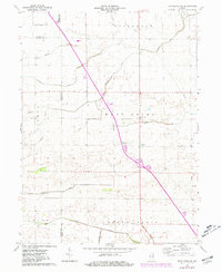
1962 Map of Templeton NE
USGS Topo · Published 1981About this map
Big Creek and Big Pine Creek anchor the drainage of this agricultural landscape, where the interplay of natural watercourses and an extensive engineered network of drainage canals like Hollingsworth Ditch and Hoagland Ditch define the territory. The map captures the meeting of several township boundaries, including West Point, Princeton, and Round Grove, revealing a rural fabric organized by section lines and water management. Local community life centers on Meadow Lake Ch and its adjacent Meadow Lake Cem, situated near the center of the survey. The presence of a Quarry and a Gravel Pit indicates the local extraction industry supporting the region's road and infrastructure development. Revisions from 1977 underscore the modernization of the corridor, including the installation of a high-pressure Pipeline and modern interstate transit features.
Find a feature on this map
24 named features on this map. Tap any name to fly to it.
Don’t see what you’re looking for? This feature index may not catch every label — zoom into the map to look around manually.
Map Details
Editions of this 1962 Templeton NE Map
3 editions found
Other maps of this area

1953 · Danville
USGS Topo · 1:250,000

1955 · Danville
USGS Topo · 1:250,000

1956 · Danville
USGS Topo · 1:250,000

1962 · Mount Gilboa
USGS Topo · 1:24,000

1962 · Brookston SW
USGS Topo · 1:24,000
1962 · Round Grove
USGS Topo · 1:24,000

1962 · Templeton NE
USGS Topo · 1:24,000

1962 · Brookston NW
USGS Topo · 1:24,000

1962 · Monon
USGS Topo · 1:24,000

1962 · Templeton
USGS Topo · 1:24,000