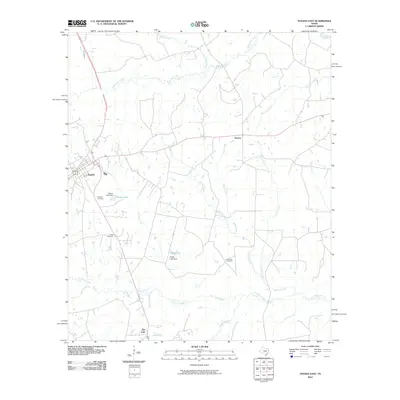
2010 Map of Tenaha East
USGS Topo · Published 2010About this map
Tenaha serves as the primary hub of this East Texas landscape, where the local economy and geography are defined by a complex network of creeks and small drainages. The area is marked by a distribution of small communities and rural intersections, including Paxton to the east and Flat Fork to the south. Water is a dominant feature throughout the quadrangle, from the northeast corner where the Sabine River flows, to the many smaller streams like Spinney Creek, Shoat Creek, and McFaddin Creek that carve through the timbered terrain. For those tracing family histories in Shelby County, the map identifies several key burial sites, including Restland Cemetery, Union Cemetery, and Lone Oak Cemetery. Notable man-made water features such as Valmac Lake and Peddy Lake, both supported by their respective dams, illustrate the local management of water resources within the Flat Fork Creek and Hilliard Creek watersheds during the early 21st century.
Find a feature on this map
23 named features on this map. Tap any name to fly to it.
Don’t see what you’re looking for? This feature index may not catch every label — zoom into the map to look around manually.
Map Details
Editions of this 2010 Tenaha East Map
This is the sole edition of this map. No revisions or reprints were ever made.
Other maps of this area

1945 · Socagee Bayou
USGS Topo · 1:62,500

1953 · Palestine
USGS Topo · 1:250,000

1956 · Tyler
USGS Topo · 1:250,000

1956 · Deadwood
USGS Topo · 1:62,500

1957 · Palestine
USGS Topo · 1:250,000

1958 · Center
USGS Topo · 1:62,500

1958 · Timpson
USGS Topo · 1:62,500

1958 · Carthage
USGS Topo · 1:62,500
1983 · Logan
USGS Topo · 1:24,000
1983 · Old Center
USGS Topo · 1:24,000