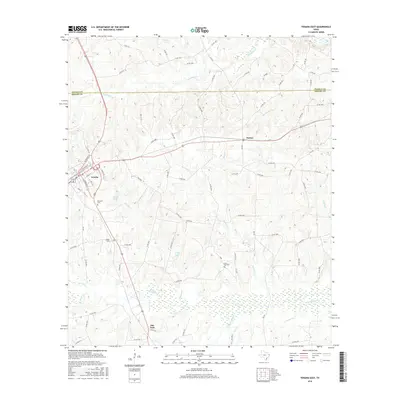
2016 Map of Tenaha East
USGS Topo · Published 2016About this map
Tenaha serves as the focal point of this East Texas survey, where the local street grid is defined by historical corridors like N Railroad St and S Center St. The map illustrates a landscape shaped by water and woods, as Hilliard Cr and Spinney Cr drain toward the southern lowlands. For genealogists, the placement of Restland Cem, Union Cem, and Lone Oak Cem provides essential spatial context for local families. The settlement at Paxton and the small collection of buildings at Flat Fork reflect the dispersed rural community structure common to this part of Shelby County. Significant water features like Valmac Lake and Peddy Lake are clearly delineated alongside the meandering path of Chicken Bayou. The border between Panola Co and Shelby Co is marked across the northern section, dividing the drainage basins of McFaddin Cr and Brushy Cr.
Find a feature on this map
87 named features on this map. Tap any name to fly to it.
Don’t see what you’re looking for? This feature index may not catch every label — zoom into the map to look around manually.
Map Details
Editions of this 2016 Tenaha East Map
This is the sole edition of this map. No revisions or reprints were ever made.
Other maps of this area

1945 · Socagee Bayou
USGS Topo · 1:62,500

1953 · Palestine
USGS Topo · 1:250,000

1956 · Tyler
USGS Topo · 1:250,000

1956 · Deadwood
USGS Topo · 1:62,500

1957 · Palestine
USGS Topo · 1:250,000

1958 · Center
USGS Topo · 1:62,500

1958 · Timpson
USGS Topo · 1:62,500

1958 · Carthage
USGS Topo · 1:62,500
1983 · Logan
USGS Topo · 1:24,000
1983 · Old Center
USGS Topo · 1:24,000