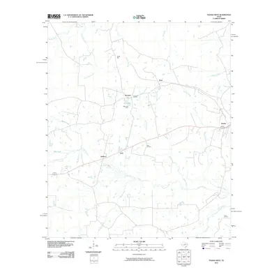
2010 Map of Tenaha West
USGS Topo · Published 2010About this map
Tenaha anchors the eastern edge of this East Texas landscape, where the local road network converges at the junction of several rail lines. The terrain is defined by a dense web of watercourses, most notably the winding Flat Fork Creek and its many tributaries like Ramsey Creek and Ship Creek. These waterways historically shaped the placement of rural settlements and family landmarks across the countryside. To the west, the community of Tennessee sits near the Tennessee Cemetery, reflecting the long-established burial sites that anchor the local genealogy of the area. Further south, smaller locales such as Bobo and Meldrum follow the path of the railroad, while Hayden Cemetery remains a significant marker in the southeastern corner. The map also captures several man-made features in the creek valleys, including Neel Lake and the Neel Lake Dam, which managed local water resources amidst the wooded hills of Shelby County.
Find a feature on this map
24 named features on this map. Tap any name to fly to it.
Don’t see what you’re looking for? This feature index may not catch every label — zoom into the map to look around manually.
Map Details
Editions of this 2010 Tenaha West Map
This is the sole edition of this map. No revisions or reprints were ever made.
Other maps of this area

1945 · Socagee Bayou
USGS Topo · 1:62,500

1953 · Palestine
USGS Topo · 1:250,000

1956 · Tyler
USGS Topo · 1:250,000

1956 · Deadwood
USGS Topo · 1:62,500

1957 · Palestine
USGS Topo · 1:250,000

1958 · Center
USGS Topo · 1:62,500

1958 · Timpson
USGS Topo · 1:62,500

1958 · Carthage
USGS Topo · 1:62,500
1983 · Old Center
USGS Topo · 1:24,000
1983 · Gary
USGS Topo · 1:24,000