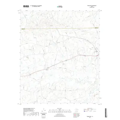
2019 Map of Tenaha West
USGS Topo · Published 2019About this map
Porter Hill stands at the center of this East Texas landscape, straddling the border between Panola and Shelby counties. This 2019 survey captures a rural environment defined by winding creek beds and family-named landmarks. The settlement of Tenaha sits at the eastern edge, while the small community of Meldrum is situated to the southwest. The terrain is deeply carved by a dense network of waterways, including Lightfoot Cr, Risinger Cr, and Flat Fork Cr, which influence the layout of the local county road system. Genealogists will find several significant burial sites, such as Tennessee Cem near Neel Lake, and Bobo Cem further south. The map provides a detailed view of these rural road networks and the way they navigate the intricate drainage basins of the Sabine River watershed.
Find a feature on this map
72 named features on this map. Tap any name to fly to it.
Don’t see what you’re looking for? This feature index may not catch every label — zoom into the map to look around manually.
Map Details
Editions of this 2019 Tenaha West Map
This is the sole edition of this map. No revisions or reprints were ever made.
Other maps of this area
1945 · Socagee Bayou
USGS Topo · 1:62,500

1953 · Palestine
USGS Topo · 1:250,000

1956 · Tyler
USGS Topo · 1:250,000
1956 · Deadwood
USGS Topo · 1:62,500

1957 · Palestine
USGS Topo · 1:250,000
1958 · Center
USGS Topo · 1:62,500
1958 · Timpson
USGS Topo · 1:62,500
1958 · Carthage
USGS Topo · 1:62,500
1983 · Old Center
USGS Topo · 1:24,000
1983 · Gary
USGS Topo · 1:24,000