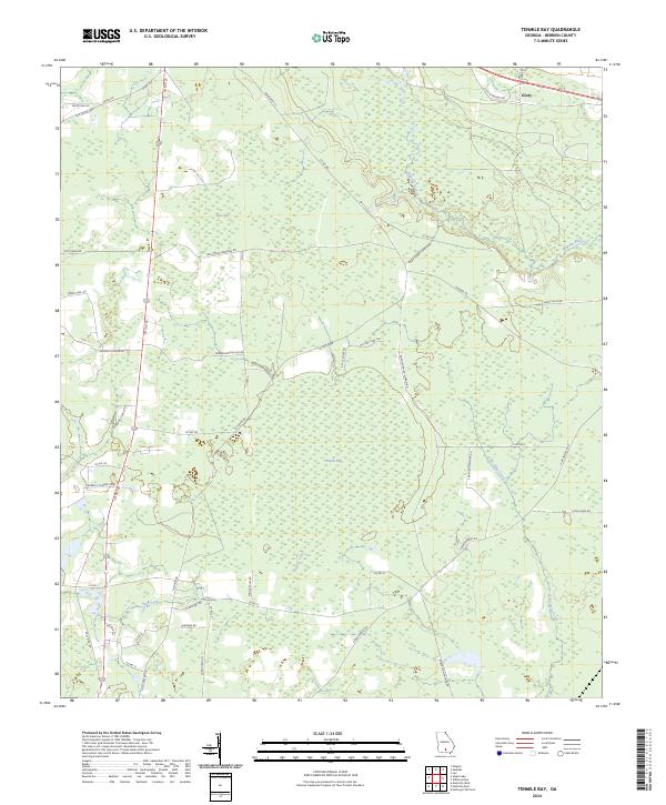
2024 Map of Tenmile Bay
USGS Topo · Published 2024About this map
Low-lying wetlands and thick vegetation define this part of Berrien County, where the massive depressions of Tenmile Bay and Tiger Bay dominate the interior landscape. The drainage of this humid basin is shaped by the wandering paths of Tenmile Creek and Fivomile Creek, which eventually reach the Alapaha River as it meanders through the eastern edge of the quadrangle. Unlike more densely populated regions, the human footprint here is represented by a network of rural roads often bearing the names of local families, such as Lilla B Gaskins Rd, Herman McClellan Rd, and Dorothy Paulk Ingram Rd.
Find a feature on this map
50 named features on this map. Tap any name to fly to it.
Don’t see what you’re looking for? This feature index may not catch every label — zoom into the map to look around manually.
Map Details
Editions of this 2024 Tenmile Bay Map
This is the sole edition of this map. No revisions or reprints were ever made.
Other maps of this area

1953 · Waycross
USGS Topo · 1:250,000

1958 · Waycross
USGS Topo · 1:250,000

1972 · Tenmile Bay
USGS Topo · 1:24,000

1972 · Willacoochee
USGS Topo · 1:24,000

1972 · Lax
USGS Topo · 1:24,000

1973 · Sapps Lake
USGS Topo · 1:24,000

1973 · Nashville West
USGS Topo · 1:24,000

1973 · Enigma
USGS Topo · 1:24,000
1977 · Alapaha
USGS Topo · 1:24,000
1977 · Hastings Fish Pond
USGS Topo · 1:24,000