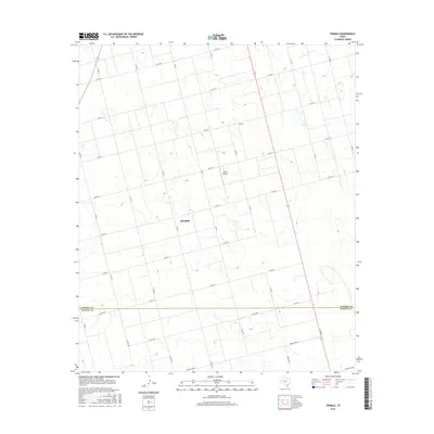
2016 Map of Tenmile
USGS Topo · Published 2016About this map
Klondike sits at the center of this 2016 survey, where the grid-like agricultural roads of the High Plains intersect. The map illustrates a landscape dominated by large-scale farming and sparse rural infrastructure, characteristic of the border region between Dawson County and Martin County. A notable landmark for aviation in this open country is Thorp Airport, located just north of the primary settlement. The terrain, labeled simply as Tenmile, is defined by subtle topographic shifts and numerous small, scattered depressions or seasonal wetlands that dot the fields. Transportation across this portion of West Texas relies on a network of numbered county roads, such as Co Rd 29 and Co Rd 30, alongside state-maintained routes like Farm Rd 2002-E.
Find a feature on this map
15 named features on this map. Tap any name to fly to it.
Don’t see what you’re looking for? This feature index may not catch every label — zoom into the map to look around manually.
Map Details
Editions of this 2016 Tenmile Map
This is the sole edition of this map. No revisions or reprints were ever made.
Other maps of this area

1954 · Hobbs
USGS Topo · 1:250,000

1954 · Big Spring
USGS Topo · 1:250,000

1958 · Big Spring
USGS Topo · 1:250,000

1958 · Hobbs
USGS Topo · 1:250,000
1966 · Wolcott Ranch
USGS Topo · 1:24,000
1966 · Merrick
USGS Topo · 1:24,000
1966 · Flower Grove
USGS Topo · 1:24,000
1970 · Patricia
USGS Topo · 1:24,000
1970 · Lamesa South
USGS Topo · 1:24,000
1970 · Key
USGS Topo · 1:24,000