
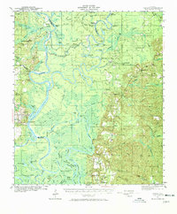
1943 Map of Tensaw
USGS Topo · Published 1958About this map
Davis Plantation and Singleton Plantation overlook the intricate river networks of the Alabama River and Mobile River during the early 1940s. The landscape is defined by its deep reliance on water transport, evidenced by a dense concentration of landings such as Betts Ldg, Boathouse Ldg, and Rice Creek Ldg. These points of entry served the rural communities of Stockton, Tensaw, and Latham, connecting isolated farmsteads and timber tracts to the outside world.
Find a feature on this map
114 named features on this map. Tap any name to fly to it.
Don’t see what you’re looking for? This feature index may not catch every label — zoom into the map to look around manually.
Map Details
Editions of this 1943 Tensaw Map
2 editions found
Other maps of this area

1941 · Bay Minette
USGS Topo · 1:62,500

1941 · Creola
USGS Topo · 1:62,500

1942 · Perdido
USGS Topo · 1:62,500

1942 · Dyas
USGS Topo · 1:62,500

1943 · Creola
USGS Topo · 1:62,500

1943 · Bay Minette
USGS Topo · 1:62,500

1943 · Choctaw Bluff
USGS Topo · 1:62,500

1943 · Citronelle
USGS Topo · 1:62,500

1943 · McIntosh
USGS Topo · 1:62,500

1944 · McIntosh
USGS Topo · 1:62,500