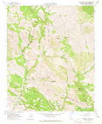
1964 Map of Tepusquet Canyon
USGS Topo · Published 1965About this map
Tepusquet Canyon and its neighbors carve a complex system of drainages through the Los Padres National Forest in this 1964 survey. The map details a landscape defined by deep-set canyons like Colson Canyon and Suey Canyon, where narrow roads follow the creek lines. Human presence is marked by family-named sites such as the Ontiveros Cem and Ruiz Grave, providing specific touchstones for genealogists researching early Santa Barbara County inhabitants.
Find a feature on this map
38 named features on this map. Tap any name to fly to it.
Don’t see what you’re looking for? This feature index may not catch every label — zoom into the map to look around manually.
Map Details
Editions of this 1964 Tepusquet Canyon Map
2 editions found
Other maps of this area

1905 · Lompoc
USGS Topo · 1:125,000

1922 · Nipomo
USGS Topo · 1:62,500

1937 · Branch Mtn
USGS Topo · 1:48,000

1942 · Lompoc
USGS Topo · 1:125,000

1942 · Santa Maria
USGS Topo · 1:62,500

1942 · Branch Mountain
USGS Topo · 1:62,500

1942 · Tepusquet Peak
USGS Topo · 1:62,500

1943 · Tepusquet Peak
USGS Topo · 1:62,500

1943 · Lompoc
USGS Topo · 1:125,000

1947 · Careaga Canyon
USGS Topo · 1:24,000