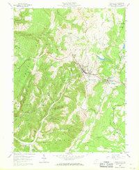
1959 Map of Terra Alta
USGS Topo · Published 1968About this map
The town of Terra Alta serves as the focal point of this late-1950s survey, situated along the critical Baltimore and Ohio railroad corridor in Preston County. The map provides significant insight into the public health infrastructure of the era, prominently featuring the State Tuberculosis Sanitarium and its associated settlement at Hopemont. This complex, alongside the local High School, underscores the community's mid-century development.
Find a feature on this map
53 named features on this map. Tap any name to fly to it.
Don’t see what you’re looking for? This feature index may not catch every label — zoom into the map to look around manually.
Map Details
Editions of this 1959 Terra Alta Map
4 editions found
Other maps of this area

1886 · St. George
USGS Topo · 1:125,000

1891 · St. George
USGS Topo · 1:125,000

1895 · Piedmont
USGS Topo · 1:125,000

1899 · Oakland
USGS Topo · 1:62,500

1900 · Accident
USGS Topo · 1:62,500

1900 · Oakland
USGS Topo · 1:62,500

1904 · Bruceton
USGS Topo · 1:62,500

1907 · Kingwood
USGS Topo · 1:62,500

1925 · Kingwood
USGS Topo · 1:62,500

1926 · Bruceton
USGS Topo · 1:62,500