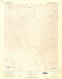
1973 Map of Terrapin Sand Point
USGS Topo · Published 1973About this map
Tangier Sound dominates this mid-1970s orthophotomap, showing the intricate interface between the Chesapeake Bay's open waters and the marshy archipelago of Somerset County. The northern reaches of Smith Island are prominently featured, where the Martin National Wildlife Refuge encompasses a network of tidal guts such as Jones Ridge Cr and Otter Creek. This specific survey, derived from 1972 aerial photography, provides a literal photographic look at the shifting shorelines of Terrapin Sand Pt and Webster Pt before contemporary erosion further altered these low-lying landforms.
Find a feature on this map
19 named features on this map. Tap any name to fly to it.
Don’t see what you’re looking for? This feature index may not catch every label — zoom into the map to look around manually.
Map Details
Editions of this 1973 Terrapin Sand Point Map
3 editions found
Other maps of this area

1898 · St. Marys
USGS Topo · 1:125,000

1903 · Crisfield
USGS Topo · 1:62,500

1903 · Bloodsworth Island
USGS Topo · 1:62,500

1903 · Deal Island
USGS Topo · 1:62,500

1906 · St. Marys
USGS Topo · 1:125,000

1917 · Ewell
USGS Topo · 1:62,500

1920 · Crisfield
USGS Topo · 1:62,500

1942 · Terrapin Sand Point
USGS Topo · 1:24,000

1942 · Kedges Straits
USGS Topo · 1:24,000

1942 · Ewell
USGS Topo · 1:24,000