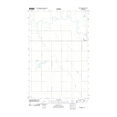
2010 Map of Terrebonne
USGS Topo · Published 2010About this map
The small settlement of Terrebonne sits at a sharp bend in the Clearwater River in Red Lake County, serving as a focal point for this agrarian landscape. Much of the surrounding territory is defined by a complex network of natural and engineered waterways, including the winding paths of Beau Gerlot Creek and Lower Badger Creek, as well as formal drainage systems like Judicial Ditch Number Sixtyfour. These features reflect the long-standing efforts to manage the wet prairies of northern Minnesota for agriculture.
Find a feature on this map
25 named features on this map. Tap any name to fly to it.
Don’t see what you’re looking for? This feature index may not catch every label — zoom into the map to look around manually.
Map Details
Editions of this 2010 Terrebonne Map
This is the sole edition of this map. No revisions or reprints were ever made.
Other maps of this area

1918 · Terrebonne
USGS Topo · 1:62,500

1918 · Red Lake Falls
USGS Topo · 1:62,500

1919 · Valley
USGS Topo · 1:62,500

1952 · Red Lake Falls
USGS Topo · 1:62,500

1952 · Grand Forks
USGS Topo · 1:250,000

1956 · Grand Forks
USGS Topo · 1:250,000
1964 · Plummer NW
USGS Topo · 1:24,000

1964 · Terrebonne
USGS Topo · 1:24,000
1964 · Plummer
USGS Topo · 1:24,000

1964 · Brooks
USGS Topo · 1:24,000