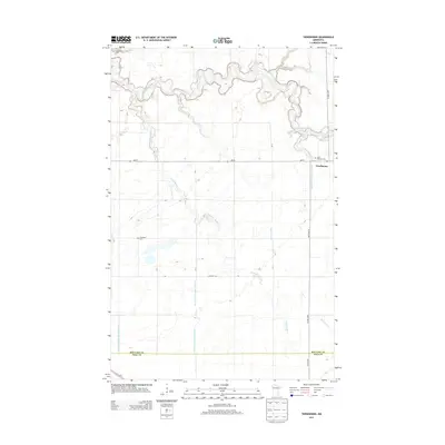
2013 Map of Terrebonne
USGS Topo · Published 2013About this map
The Clearwater River snakes across the northern reaches of this landscape, its tight oxbows and meanders defining the drainage of the Red River Valley floor. The small settlement of Terrebonne sits at the junction of MN-92 and Terrebonne Cr, serving as a central point for a region deeply modified by water management. The extensive network of engineered waterways, including Judicial Ditch Number Sixtyseven and County Ditch Number Fiftyeight, illustrates the area's transition from prairie wetlands to highly productive agricultural land. Family and local history are preserved at several rural burial sites scattered across the township lines, notably Saint Anthony Cem near the town site, and Evergreen Cem and Oak Grove Cem situated further afield among the creek branches.
Find a feature on this map
18 named features on this map. Tap any name to fly to it.
Don’t see what you’re looking for? This feature index may not catch every label — zoom into the map to look around manually.
Map Details
Editions of this 2013 Terrebonne Map
This is the sole edition of this map. No revisions or reprints were ever made.
Other maps of this area

1918 · Terrebonne
USGS Topo · 1:62,500

1918 · Red Lake Falls
USGS Topo · 1:62,500

1919 · Valley
USGS Topo · 1:62,500

1952 · Red Lake Falls
USGS Topo · 1:62,500

1952 · Grand Forks
USGS Topo · 1:250,000

1956 · Grand Forks
USGS Topo · 1:250,000
1964 · Plummer NW
USGS Topo · 1:24,000

1964 · Terrebonne
USGS Topo · 1:24,000
1964 · Plummer
USGS Topo · 1:24,000

1964 · Brooks
USGS Topo · 1:24,000