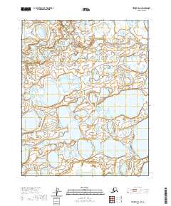
2020 Map of Teshekpuk B-1 SE
USGS Topo · Published 2020About this map
Kealok Creek winds through an intricate landscape of thaw lakes and wetlands in this northern coastal plain region of the North Slope. The terrain is characterized by the Pik Dunes in the southern portion of the quadrangle, which rise above the surrounding saturated tundra and myriad water bodies. Mapping by the U.S. Geological Survey reveals a complex hydrological network where the distinctions between land and water are constantly shifting, typical of the permafrost-influenced Arctic environment. The lack of permanent structures or roads emphasizes the isolation of this corner of Alaska, preserved here as it appeared in the early 21st century.
Find a feature on this map
11 named features on this map. Tap any name to fly to it.
Don’t see what you’re looking for? This feature index may not catch every label — zoom into the map to look around manually.
Map Details
Editions of this 2020 Teshekpuk B-1 SE Map
This is the sole edition of this map. No revisions or reprints were ever made.
Other maps of this area

1951 · Harrison Bay
USGS Topo · 1:250,000

1951 · Teshekpuk
USGS Topo · 1:250,000

1955 · Harrison Bay
USGS Topo · 1:250,000

1955 · Teshekpuk
USGS Topo · 1:250,000

1955 · Teshekpuk A-1
USGS Topo · 1:63,360

1955 · Teshekpuk B-1
USGS Topo · 1:63,360

1955 · Harrison Bay B-5
USGS Topo · 1:63,360

1955 · Harrison Bay A-5
USGS Topo · 1:63,360

1964 · Teshekpuk
USGS Topo · 1:250,000
2013 · Harrison Bay B-5 SW
USGS Topo · 1:25,000