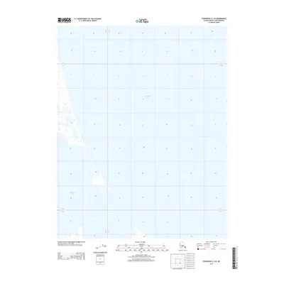
2013 Map of Teshekpuk C-2 SE
USGS Topo · Published 2013About this map
Teshekpuk Lake dominates this Arctic coastal plain landscape, where the vast expanse of water and seasonal wetlands define the geography. The survey depicts a segment of the North Slope's complex hydrological system, primarily showing the deep reach of the lake into the southern and western portions of the quadrangle. The land is strictly organized by the Public Land Survey System, with township and range lines such as T 14 N and R 8 W and R 7 W providing the only terrestrial reference points across the low-lying tundra. This map illustrates the intersection of immense natural water bodies and the administrative grids used to manage one of the most northern reaches of the United States.
Find a feature on this map
5 named features on this map. Tap any name to fly to it.
Don’t see what you’re looking for? This feature index may not catch every label — zoom into the map to look around manually.
Map Details
Editions of this 2013 Teshekpuk C-2 SE Map
This is the sole edition of this map. No revisions or reprints were ever made.
Other maps of this area

1951 · Teshekpuk
USGS Topo · 1:250,000

1955 · Teshekpuk
USGS Topo · 1:250,000
1955 · Teshekpuk B-2
USGS Topo · 1:63,360

1955 · Teshekpuk B-1
USGS Topo · 1:63,360
1955 · Teshekpuk C-2
USGS Topo · 1:63,360
1955 · Teshekpuk C-1
USGS Topo · 1:63,360
1962 · Teshekpuk C-2
USGS Topo · 1:50,000

1964 · Teshekpuk
USGS Topo · 1:250,000
1982 · Teshekpuk B-2
USGS Topo · 1:63,360
2013 · Teshekpuk B-2 NW
USGS Topo · 1:25,000