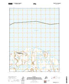
2020 Map of Teshekpuk D-1 NE
USGS Topo · Published 2020About this map
The Beaufort Sea coast of the North Slope appears as a shifting mosaic of Arctic wetlands and narrow barrier lands in this modern study. The Smith River meanders through a landscape defined by thermokarst lakes and coastal tundra, eventually reaching the sea near the geographical marker of Pitt Point. This remote stretch of coastline is anchored by the Lonely Air Station, a Cold War-era facility that remains a critical point of human activity in an otherwise unpopulated Arctic terrain. Inland, the terrain features of Kokruagarok characterize the low-lying coastal plain where land and water blur during seasonal shifts. The map illustrates the complex hydrography of the region, where countless small pools and river channels define the geography south of the Beaufort coastline.
Find a feature on this map
8 named features on this map. Tap any name to fly to it.
Don’t see what you’re looking for? This feature index may not catch every label — zoom into the map to look around manually.
Map Details
Editions of this 2020 Teshekpuk D-1 NE Map
This is the sole edition of this map. No revisions or reprints were ever made.
Other maps of this area

1951 · Harrison Bay
USGS Topo · 1:250,000

1951 · Teshekpuk
USGS Topo · 1:250,000

1955 · Harrison Bay
USGS Topo · 1:250,000

1955 · Teshekpuk
USGS Topo · 1:250,000

1955 · Harrison Bay D-5
USGS Topo · 1:63,360

1955 · Teshekpuk D-1
USGS Topo · 1:63,360
1962 · Harrison Bay D-5
USGS Topo · 1:50,000

1964 · Teshekpuk
USGS Topo · 1:250,000
2013 · Teshekpuk D-1 SE
USGS Topo · 1:25,000
2016 · Teshekpuk D-1 SW
USGS Topo · 1:25,000