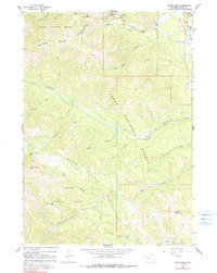
1963 Map of Teton Pass
USGS Topo · Published 1991About this map
Teton Pass stands as the central gateway through the Snake River Range, marking a rugged transition point between the Targhee National Forest and Teton National Forest. This 1963 survey captures the landscape just as the area was beginning to solidify its identity as a mountain destination, featuring the Trail Creek Ranch and the Lee Guard Station. The small settlement of Wilson is visible in the upper right, situated near the confluence of Fish Creek and the Snake River. Local history is anchored at the Elliott Cem, while the terrain is defined by dramatic features like the Glory Slide and Smoky Hollow Peak. The map documents a network of primitive transportation, including a Pack Trail winding through Adams Canyon and Smoky Hollow, illustrating the early reliance on pack animal routes through the high timber.
Find a feature on this map
37 named features on this map. Tap any name to fly to it.
Don’t see what you’re looking for? This feature index may not catch every label — zoom into the map to look around manually.
Map Details
Editions of this 1963 Teton Pass Map
3 editions found

Other maps of this area

1899 · Grand Teton
USGS Topo · 1:125,000

1901 · Grand Teton
USGS Topo · 1:125,000

1931 · Jackson
USGS Topo · 1:125,000

1932 · Irwin
USGS Topo · 1:96,000

1935 · Irwin
USGS Topo · 1:125,000

1935 · Jackson
USGS Topo · 1:125,000

1943 · Driggs
USGS Topo · 1:62,500

1946 · Driggs
USGS Topo · 1:62,500

1955 · Driggs
USGS Topo · 1:250,000

1958 · Driggs
USGS Topo · 1:250,000