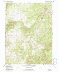
1964 Map of Texas Creek
USGS Topo · Published 1986About this map
Dragon Trail cuts through the high desert landscape of Rio Blanco County, tracing a path through a region defined by its complex drainage systems and early energy exploration. Surveyed in the mid-1960s, this area shows a transition from traditional land use to industrial activity, evidenced by the numerous Gas Well and Drill Hole locations scattered across the plateaus. The northern portion is dominated by the Red Wash system, including the West Fork and East Fork, which feed into the Red Wash Reservoir.
Find a feature on this map
17 named features on this map. Tap any name to fly to it.
Don’t see what you’re looking for? This feature index may not catch every label — zoom into the map to look around manually.
Map Details
Editions of this 1964 Texas Creek Map
3 editions found
Other maps of this area

1885 · East Tavaputs
USGS Topo · 1:250,000

1956 · Grand Junction
USGS Topo · 1:250,000

1959 · Grand Junction
USGS Topo · 1:250,000

1960 · Grand Junction
USGS Topo · 1:250,000

1962 · Grand Junction
USGS Topo · 1:250,000

1964 · Grand Junction
USGS Topo · 1:250,000

1964 · Texas Creek
USGS Topo · 1:24,000

1964 · East Evacuation Creek
USGS Topo · 1:24,000
1964 · Water Canyon
USGS Topo · 1:24,000
1964 · Texas Mountain
USGS Topo · 1:24,000