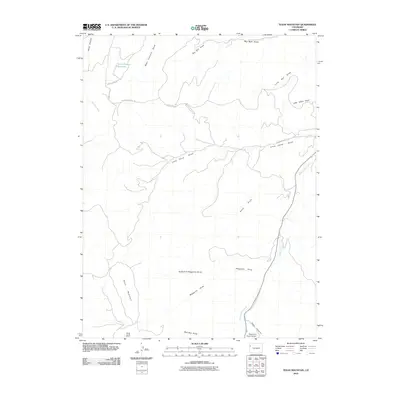
2010 Map of Texas Mountain
USGS Topo · Published 2010About this map
Texas Mountain stands as a prominent topographical feature in this high-desert landscape of Rio Blanco County, characterized by a complex network of seasonal drainages and canyons. The presence of the Water Canyon Reservoir at the head of Water Canyon suggests a managed water system in an otherwise arid environment. Evidence of back-country access is seen in the path of the Dragon Douglas Trl and various unpaved routes like County Rd 107, which navigate the steep terrain between Big Bull Draw and Little Horse Draw. The map details a significant watershed system including West Douglas Creek and the Right Fork Waggoner Draw, illustrating how the geography is defined by erosion and runoff. This 2010 survey records the intricate network of naming conventions for local landforms, from Mail Box Draw to Rope Canyon, providing a precise look at the rural character and land use of the region.
Find a feature on this map
20 named features on this map. Tap any name to fly to it.
Don’t see what you’re looking for? This feature index may not catch every label — zoom into the map to look around manually.
Map Details
Editions of this 2010 Texas Mountain Map
This is the sole edition of this map. No revisions or reprints were ever made.
Other maps of this area

1956 · Grand Junction
USGS Topo · 1:250,000

1959 · Grand Junction
USGS Topo · 1:250,000

1960 · Grand Junction
USGS Topo · 1:250,000

1962 · Grand Junction
USGS Topo · 1:250,000

1964 · Grand Junction
USGS Topo · 1:250,000

1964 · Texas Creek
USGS Topo · 1:24,000

1964 · Brushy Point
USGS Topo · 1:24,000
1964 · Philadelphia Creek
USGS Topo · 1:24,000

1964 · East Evacuation Creek
USGS Topo · 1:24,000
1964 · Water Canyon
USGS Topo · 1:24,000