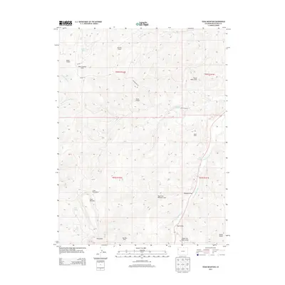
2013 Map of Texas Mountain
USGS Topo · Published 2013About this map
Texas Mountain dominates this high-altitude landscape of Rio Blanco County, where a complex network of draws and canyons defines the drainage patterns of the western slope. Water is the primary architect of the terrain, from the West Douglas Creek basin in the southeast to the upper reaches of North Fork Texas Creek. High-country water management is evident at Water Canyon Reservoir and Little Horse Reservoir, alongside natural sources like Wild Rose Spring and Sand Spring. The map documents a rugged interior traversed by primitive routes including the Dragon Douglas Trl and Co Road 116. Named landmarks such as Mail Box Draw and Rope Canyon reflect a ranching and backcountry heritage, while the extensive system of draws—including Big Bull Draw and Waggoner Draw—illustrates the intricate erosion patterns typical of this Colorado plateau region.
Find a feature on this map
30 named features on this map. Tap any name to fly to it.
Don’t see what you’re looking for? This feature index may not catch every label — zoom into the map to look around manually.
Map Details
Editions of this 2013 Texas Mountain Map
This is the sole edition of this map. No revisions or reprints were ever made.
Other maps of this area

1956 · Grand Junction
USGS Topo · 1:250,000

1959 · Grand Junction
USGS Topo · 1:250,000

1960 · Grand Junction
USGS Topo · 1:250,000

1962 · Grand Junction
USGS Topo · 1:250,000

1964 · Grand Junction
USGS Topo · 1:250,000

1964 · Texas Creek
USGS Topo · 1:24,000

1964 · Brushy Point
USGS Topo · 1:24,000
1964 · Philadelphia Creek
USGS Topo · 1:24,000

1964 · East Evacuation Creek
USGS Topo · 1:24,000
1964 · Water Canyon
USGS Topo · 1:24,000