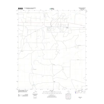
2012 Map of Texon
USGS Topo · Published 2012About this map
Texon and Santa Rita anchor this Reagan County landscape, reflecting the specialized settlement patterns of the West Texas oil fields. The map detail highlights a network of ranch and access roads, including Ranch Road 1555 and Texon Rd, which connect these small industrial and residential nodes to the surrounding territory. The arid environment is defined by its water management infrastructure, evidenced by numerous named landmarks such as Mustang Windmill, West Windmill, and Joyner Windmill. Further south, Lone Wolf Camp sits near the headwaters of Live Oak Cr, while Grierson Springs marks a rare natural water source in a region otherwise reliant on catchments like Alta Loma Tank and Pipeline Tank. This survey captures the utilitarian geography of a region shaped by both ranching traditions and petroleum heritage.
Find a feature on this map
17 named features on this map. Tap any name to fly to it.
Don’t see what you’re looking for? This feature index may not catch every label — zoom into the map to look around manually.
Map Details
Editions of this 2012 Texon Map
This is the sole edition of this map. No revisions or reprints were ever made.
Other maps of this area

1928 · Rankin
USGS Topo · 1:125,000

1954 · San Angelo
USGS Topo · 1:250,000

1958 · San Angelo
USGS Topo · 1:250,000

1965 · San Angelo
USGS Topo · 1:250,000

1970 · Sevenmile Corner SE
USGS Topo · 1:24,000
1970 · Rankin SE
USGS Topo · 1:24,000
1970 · Texon SE
USGS Topo · 1:24,000
1970 · Rankin NE
USGS Topo · 1:24,000

1970 · Garrison Draw
USGS Topo · 1:24,000

1970 · Gardener Draw
USGS Topo · 1:24,000