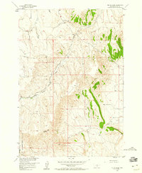
1956 Map of The Big Slide
USGS Topo · Published 1960About this map
The dramatic geological feature known as The Big Slide anchors this mid-century survey of the Carbon County landscape. Situated within the Missouri River Basin development program, the area is defined by a dendritic network of drainages including Elbow Creek, Cherry Creek, and Cedar Creek. Local infrastructure is sparse, characterized primarily by the Loyning Sch and an early pipeline corridor, reflecting the rural and industrial evolution of the region in the 1950s. The topography transitions from the high elevations of the northwest down toward the Dry Creek Basin and the meandering Sand Creek in the southeast. Named landmarks like Gramps and Chappel Cr provide specific points of interest for genealogists and local historians tracing the settlement patterns of this Montana terrain.
Find a feature on this map
14 named features on this map. Tap any name to fly to it.
Don’t see what you’re looking for? This feature index may not catch every label — zoom into the map to look around manually.
Map Details
Editions of this 1956 The Big Slide Map
2 editions found
Other maps of this area

1932 · Red Lodge No 1
USGS Topo · 1:48,000

1944 · Red Lodge
USGS Topo · 1:62,500

1954 · Billings
USGS Topo · 1:250,000

1956 · Bridger
USGS Topo · 1:24,000

1956 · Fromberg
USGS Topo · 1:24,000

1956 · Roberts
USGS Topo · 1:24,000
1956 · Boyd
USGS Topo · 1:24,000

1956 · The Big Slide
USGS Topo · 1:24,000
1956 · Cooney Reservoir
USGS Topo · 1:24,000

1957 · Billings
USGS Topo · 1:250,000