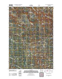
2011 Map of The Cockscomb
USGS Topo · Published 2011About this map
The North Fork John Day River carves through the northern reaches of this landscape, anchoring a network of remote basins and high-altitude meadows. This 2011 survey reveals a territory shaped by drainage patterns and resource extraction, most notably at the Blue Bucket Mine near the southern boundary. Significant terrain features like The Cockscomb and Turner Basin provide geographical context for the numerous seasonal water sources and springs, including Mote Spring and Big Springs.
Find a feature on this map
22 named features on this map. Tap any name to fly to it.
Don’t see what you’re looking for? This feature index may not catch every label — zoom into the map to look around manually.
Map Details
Editions of this 2011 The Cockscomb Map
This is the sole edition of this map. No revisions or reprints were ever made.
Other maps of this area

1951 · Dale
USGS Topo · 1:62,500

1951 · Desolation Butte
USGS Topo · 1:62,500

1953 · Pendleton
USGS Topo · 1:250,000

1955 · Canyon City
USGS Topo · 1:250,000

1956 · Pendleton
USGS Topo · 1:250,000

1959 · Canyon City
USGS Topo · 1:250,000

1967 · Ukiah SE
USGS Topo · 1:24,000

1967 · Pearson Ridge
USGS Topo · 1:24,000

1967 · Bridge Creek
USGS Topo · 1:24,000
1979 · La Grande
USGS Topo · 1:100,000