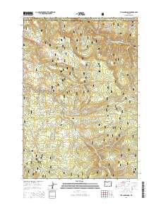
2014 Map of The Cockscomb
USGS Topo · Published 2014About this map
Umatilla National Forest encompasses the high country of this Blue Mountains landscape, split by the boundary between Umatilla and Grant Counties. The terrain is defined by a series of meadows and basins, including Turner Meadow, Round Meadows, and Wassen Meadows, which serve as catchments for the headwaters of numerous creeks. The North Fork John Day River cuts through the northeast corner, while the central ridge features the distinctive formation known as The Cockscomb.
Find a feature on this map
48 named features on this map. Tap any name to fly to it.
Don’t see what you’re looking for? This feature index may not catch every label — zoom into the map to look around manually.
Map Details
Editions of this 2014 The Cockscomb Map
This is the sole edition of this map. No revisions or reprints were ever made.
Other maps of this area

1951 · Dale
USGS Topo · 1:62,500

1951 · Desolation Butte
USGS Topo · 1:62,500

1953 · Pendleton
USGS Topo · 1:250,000

1955 · Canyon City
USGS Topo · 1:250,000

1956 · Pendleton
USGS Topo · 1:250,000

1959 · Canyon City
USGS Topo · 1:250,000

1967 · Ukiah SE
USGS Topo · 1:24,000

1967 · Pearson Ridge
USGS Topo · 1:24,000

1967 · Bridge Creek
USGS Topo · 1:24,000
1979 · La Grande
USGS Topo · 1:100,000