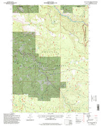
1995 Map of The Cockscomb
USGS Topo · Published 1998About this map
North Fork John Day River defines the northeastern corner of this terrain, where it forms a natural boundary within the Umatilla National Forest. The landscape is dominated by a series of high ridges and deep drainages, most notably the prominent rocky spine of The Cockscomb. During this mid-1990s period, the area remained largely undeveloped, characterized by a complex network of 4WD trails and primitive campsites.
Find a feature on this map
34 named features on this map. Tap any name to fly to it.
Don’t see what you’re looking for? This feature index may not catch every label — zoom into the map to look around manually.
Map Details
Editions of this 1995 The Cockscomb Map
This is the sole edition of this map. No revisions or reprints were ever made.
Other maps of this area

1951 · Dale
USGS Topo · 1:62,500

1951 · Desolation Butte
USGS Topo · 1:62,500

1953 · Pendleton
USGS Topo · 1:250,000

1955 · Canyon City
USGS Topo · 1:250,000

1956 · Pendleton
USGS Topo · 1:250,000

1959 · Canyon City
USGS Topo · 1:250,000

1967 · Ukiah SE
USGS Topo · 1:24,000

1967 · Pearson Ridge
USGS Topo · 1:24,000

1967 · Bridge Creek
USGS Topo · 1:24,000
1979 · La Grande
USGS Topo · 1:100,000