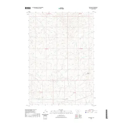
2020 Map of The Dugout
USGS Topo · Published 2020About this map
The Dugout marks a point of human interest in this corner of Big Horn County, where the landscape is defined by a dense network of intermittent watercourses. Drainage systems like Ninemile Cr and its tributary Little Ninemile Cr carve through the terrain, while Dry Cr and Little Dry Cr suggest a seasonal cycle common to the Montana plains. The topography is punctuated by Haystack Butte, providing a significant vertical landmark in an area otherwise characterized by the branching valleys of Big Meadow Cr and Lazy Man Cr. This survey illustrates the relationship between the natural drainage patterns and the established township and range boundaries, showing how water sources dictated the early geographic framework of the region.
Find a feature on this map
16 named features on this map. Tap any name to fly to it.
Don’t see what you’re looking for? This feature index may not catch every label — zoom into the map to look around manually.
Map Details
Editions of this 2020 The Dugout Map
This is the sole edition of this map. No revisions or reprints were ever made.
Other maps of this area

1894 · Fort Custer
USGS Topo · 1:125,000

1954 · Hardin
USGS Topo · 1:250,000

1957 · Hardin
USGS Topo · 1:250,000

1958 · Hardin
USGS Topo · 1:250,000

1960 · Foster
USGS Topo · 1:24,000

1960 · Ninemile Point
USGS Topo · 1:24,000

1960 · Hardin
USGS Topo · 1:24,000

1967 · Crow Agency NE
USGS Topo · 1:24,000
1967 · Little Dry Creek
USGS Topo · 1:24,000
1972 · The Dugout
USGS Topo · 1:24,000