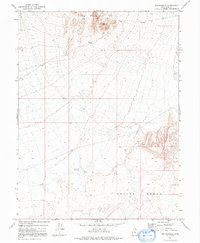
1971 Map of The Hogback
USGS Topo · Published 1991About this map
Keg Mountain dominates the northern horizon of this high-desert landscape in Juab County, transitioning into the broad expanse of Crater Bench to the south. Mapped in the early 1970s, the terrain reveals a sparse network of 4WD tracks and limited water resources essential for rangeland management. Evidence of local livestock operations appears in isolated features like the Corral in the northeast and a lone Well situated in the central flats. The topography is defined by the sharp rise of The Hogback, a prominent ridge that overlooks the Hogback Reservoir. These markers suggest a landscape primarily utilized for seasonal grazing and remote resource extraction, where every named water source was a critical waypoint for those navigating the arid basin and range territory.
Find a feature on this map
9 named features on this map. Tap any name to fly to it.
Don’t see what you’re looking for? This feature index may not catch every label — zoom into the map to look around manually.
Map Details
Editions of this 1971 The Hogback Map
2 editions found
Other maps of this area

1885 · Sevier Desert
USGS Topo · 1:250,000

1953 · Delta
USGS Topo · 1:250,000

1958 · Delta
USGS Topo · 1:250,000

1962 · Delta
USGS Topo · 1:250,000

1971 · Baker Hot Springs
USGS Topo · 1:24,000

1971 · Picture Rock Hills
USGS Topo · 1:24,000

1971 · Drum Mts Well
USGS Topo · 1:24,000

1971 · Crater Bench Reservoir
USGS Topo · 1:24,000
1971 · Keg Mtn Ranch
USGS Topo · 1:24,000

1971 · Fumarole Butte
USGS Topo · 1:24,000