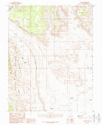
1987 Map of The Post
USGS Topo · Published 1987About this map
Waterpocket Fold dominates this 1987 survey, revealing the dramatic geologic staircase that defines the boundary of Capitol Reef National Park. The landscape is characterized by its verticality, from the high plateau of Swap Mesa and Cave Point down into the narrow corridors of Grand Gulch and Butt Canyon. Historically, this area served as a remote outpost for livestock and travel through the fold, evidenced by The Post and various seasonal water sources like Cottonwood Tanks, Willow Tanks, and Thompson Seep. The drainage of Halls Creek snakes through the lowlands, providing a natural passage through an otherwise impassable reef of stone. Other landmarks include a Natural Bridge and the Brush Corral Reservoir, indicating the sparse but vital human infrastructure required for ranching in this arid Garfield County terrain.
Find a feature on this map
22 named features on this map. Tap any name to fly to it.
Don’t see what you’re looking for? This feature index may not catch every label — zoom into the map to look around manually.
Map Details
Editions of this 1987 The Post Map
2 editions found
Other maps of this area

1886 · Escalante
USGS Topo · 1:250,000

1886 · Henry Mountains
USGS Topo · 1:250,000

1892 · Henry Mountains
USGS Topo · 1:250,000

1952 · Mt Pennell 2 NE
USGS Topo · 1:24,000

1953 · Mt Pennell
USGS Topo · 1:62,500

1953 · Circle Cliffs 1 SE
USGS Topo · 1:24,000

1953 · Mt Pennell 2 SE
USGS Topo · 1:24,000

1953 · Mt Pennell 3 NW
USGS Topo · 1:24,000
1953 · Circle Cliffs 1 NE
USGS Topo · 1:24,000

1953 · Mt Pennell 2 SW
USGS Topo · 1:24,000