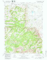
1953 Map of The Q Ranch
USGS Topo · Published 1980About this map
The Q Ranch and its neighboring livestock operations define this mid-century landscape in the high desert of the Shirley Basin. The 1953 field check captures a period of ranching and early mineral exploration, including the Iron Mine (Inactive) located south of Prior Flat. The terrain is marked by dramatic elevation changes rising toward Moccasin and Bald Mountain, where water management is critical for survival. Evidence of hydraulic engineering is visible through an extensive network of human-made infrastructure, including a Ditch system and a Flume carrying water from Grinnell Creek to support the basin's arid pastures. From the remote Cave Creek Ranch to the curiously named geologic feature The Sinks, the map provides a high-resolution look at the drainage patterns of Troublesome Creek and Cottonwood Creek before modern developments altered the region's character.
Find a feature on this map
35 named features on this map. Tap any name to fly to it.
Don’t see what you’re looking for? This feature index may not catch every label — zoom into the map to look around manually.
Map Details
Editions of this 1953 The Q Ranch Map
4 editions found
Other maps of this area

1953 · Fourmile Point
USGS Topo · 1:24,000

1953 · Fourmile Ridge
USGS Topo · 1:24,000

1953 · Schneider Ridge
USGS Topo · 1:24,000

1953 · The Q Ranch
USGS Topo · 1:24,000

1953 · T E Ranch
USGS Topo · 1:24,000

1953 · Beaver Creek
USGS Topo · 1:24,000

1955 · Casper
USGS Topo · 1:250,000

1958 · Casper
USGS Topo · 1:250,000

1960 · Wild Irish Reservoir
USGS Topo · 1:24,000
1961 · Pine Hill
USGS Topo · 1:24,000