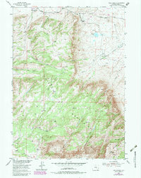
1953 Map of The Q Ranch
USGS Topo · Published 1983About this map
The Shirley Mountains dominate this high-altitude landscape in Carbon County, Wyoming, revealing a rugged ranching and mining history. Several established homesteads such as The Q Ranch, Old Dolling Ranch, and First Ranch are situated along the drainage systems of the mountains, suggesting a reliance on the scattered water sources of the high desert. In the northern reaches, Prior Flat provides a level break in the terrain near Cave Creek Ranch. Historical industrial activity is evidenced by an Iron Mine (Inactive) on the northern slopes, while unusual geological features like The Sinks on Bear Creek point to the area's complex hydrology. The presence of Ruins near the southern peaks and the remote Grinnell Lake underscore the isolation of these uplands during the mid-20th century.
Find a feature on this map
27 named features on this map. Tap any name to fly to it.
Don’t see what you’re looking for? This feature index may not catch every label — zoom into the map to look around manually.
Map Details
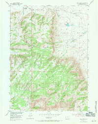
Editions of this 1953 The Q Ranch Map
4 editions found
Other maps of this area

1953 · Fourmile Point
USGS Topo · 1:24,000

1953 · Fourmile Ridge
USGS Topo · 1:24,000

1953 · Schneider Ridge
USGS Topo · 1:24,000

1953 · The Q Ranch
USGS Topo · 1:24,000

1953 · T E Ranch
USGS Topo · 1:24,000

1953 · Beaver Creek
USGS Topo · 1:24,000

1955 · Casper
USGS Topo · 1:250,000

1958 · Casper
USGS Topo · 1:250,000

1960 · Wild Irish Reservoir
USGS Topo · 1:24,000
1961 · Pine Hill
USGS Topo · 1:24,000