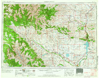
1958 Map of Thermopolis
USGS Topo · Published 1958About this map
Wind River Indian Reservation dominates the southern landscape of this mid-century survey, showing a complex network of settlements including Fort Washakie and Ethete. The central geography is defined by the Wind River flowing into the newly formed Boysen Reservoir, a critical water management feature for the Wind River Basin. To the north, the petroleum industry is prominent, with the Hamilton Dome Oil Field, Grass Creek Oil Field, and Waugh Oil Field indicating the era's energy extraction footprint.
Find a feature on this map
94 named features on this map. Tap any name to fly to it.
Don’t see what you’re looking for? This feature index may not catch every label — zoom into the map to look around manually.
Map Details
Editions of this 1958 Thermopolis Map
2 editions found

Other maps of this area

1885 · Lake
USGS Topo · 1:125,000

1893 · Ishawooa
USGS Topo · 1:125,000

1895 · Ishawooa
USGS Topo · 1:125,000

1895 · Lake
USGS Topo · 1:125,000

1896 · Lake
USGS Topo · 1:125,000

1899 · Ishawooa
USGS Topo · 1:125,000

1901 · Lake
USGS Topo · 1:125,000

1902 · Mt Leidy
USGS Topo · 1:125,000

1904 · Kirwin
USGS Topo · 1:125,000

1905 · Younts Peak
USGS Topo · 1:125,000