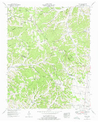
1951 Map of Theta
USGS Topo · Published 1975About this map
The Williamson and Maury County line divides this landscape of sharp ridges and deep hollows, captured just before the mid-century. The Duck River Divide and Natchez Trace Ridge define the local topography, creating a series of isolated valleys where rural life centered around local landmarks like Mt Bethel Ch and the Chestnut Ridge Church. This era shows a network of family-named cemeteries such as Carlisle Cem and Tidwell Cem, alongside small rural institutions like Parham Sch. Settlement patterns follow the winding watercourses, notably Leipers Creek and Carters Creek, where the small communities of Theta and Boston serve as anchor points. The presence of Mobley Cut along the railroad and natural features like Stanley Cave highlight the intersection of geographic necessity and geological curiosity in this part of Tennessee.
Find a feature on this map
90 named features on this map. Tap any name to fly to it.
Don’t see what you’re looking for? This feature index may not catch every label — zoom into the map to look around manually.
Map Details
Editions of this 1951 Theta Map
4 editions found
Other maps of this area

1901 · Colombia
USGS Topo · 1:125,000

1909 · Franklin
USGS Topo · 1:62,500

1936 · Godwin
USGS Topo · 1:24,000

1936 · Williamsport
USGS Topo · 1:24,000

1936 · Primm
USGS Topo · 1:24,000

1936 · Spring Hill
USGS Topo · 1:24,000

1936 · Theta
USGS Topo · 1:24,000

1936 · Carters Creek
USGS Topo · 1:24,000

1936 · Craigfield
USGS Topo · 1:24,000

1940 · Godwin
USGS Topo · 1:24,000