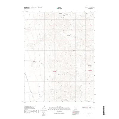
2018 Map of Third Butte East
USGS Topo · Published 2018About this map
The high-elevation ridges of the Snake Range dominate this Nevada landscape, defined by a series of prominent peaks including First Butte, Second Butte, and Third Butte. This 2018 survey reveals a terrain shaped by dramatic drainage systems like White Cloud Canyon and Cottonwood Canyon, where seasonal water sources are vital. These specific locations, including Marble Spring and the curiously named Ptomaine Springs, suggest essential stopping points in an otherwise arid environment. Along the western edge, the land descends toward Spring Valley, while White Pine Co Road 37 provides the primary transit corridor through the lower elevations. The map provides a detailed view of these natural landmarks, such as O'Neal Peak and White Cloud Mtn, which have long served as navigational aids for those traversing this part of the Great Basin.
Find a feature on this map
28 named features on this map. Tap any name to fly to it.
Don’t see what you’re looking for? This feature index may not catch every label — zoom into the map to look around manually.
Map Details
Editions of this 2018 Third Butte East Map
This is the sole edition of this map. No revisions or reprints were ever made.
Other maps of this area

1956 · Ely
USGS Topo · 1:250,000

1959 · Ely
USGS Topo · 1:250,000

1963 · Ely
USGS Topo · 1:250,000
1986 · Mount Moriah
USGS Topo · 1:24,000
1986 · Third Butte West
USGS Topo · 1:24,000
1986 · Yelland Dry Lake
USGS Topo · 1:24,000
1986 · Big Hard Pan
USGS Topo · 1:24,000
1986 · Sixmile Canyon
USGS Topo · 1:24,000
1986 · Mormon Jack Pass
USGS Topo · 1:24,000
1986 · White Cloud Point
USGS Topo · 1:24,000