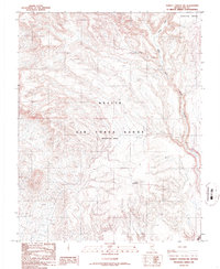
1986 Map of Thirsty Canyon NW
USGS Topo · Published 1986About this map
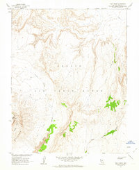
Nellis Air Force Range (Restricted Area) occupies the majority of this desert landscape, defined by steep topographic shifts and isolated high points. The terrain transitions from the high plateau of Pahute Mesa in the north toward the distinct peak of Thirsty Mountain further south. This 1986 edition documents a landscape used primarily for military training and geological exploration during the late Cold War period. Evidence of human activity is sparse but significant, marked by a single Prospect and the label Sleeping near the western boundary. Drainage patterns are dominated by the deep incisions of Left Fork Thirsty Canyon, which cuts through the volcanic geology common to this portion of Nye County.
Find a feature on this map
7 named features on this map. Tap any name to fly to it.
Don’t see what you’re looking for? This feature index may not catch every label — zoom into the map to look around manually.
Map Details
Editions of this 1986 Thirsty Canyon NW Map
This is the sole edition of this map. No revisions or reprints were ever made.
Other maps of this area

1908 · Kawich
USGS Topo · 1:250,000

1942 · Tolicha Peak
USGS Topo · 1:125,000
1952 · Black Mtn
USGS Topo · 1:62,500

1954 · Goldfield
USGS Topo · 1:250,000

1955 · Goldfield
USGS Topo · 1:250,000

1958 · Goldfield
USGS Topo · 1:250,000

1962 · Goldfield
USGS Topo · 1:250,000
1962 · Thirsty Canyon SE
USGS Topo · 1:24,000
1962 · Thirsty Canyon
USGS Topo · 1:24,000
1962 · Trail Ridge
USGS Topo · 1:24,000