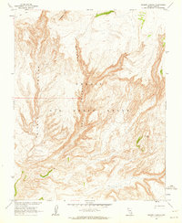
1962 Map of Thirsty Canyon
USGS Topo · Published 1964About this map
Nellis Air Force Range dominates this 1962 landscape in Nye County, Nevada, where the desert floor is carved into a complex drainage system. The primary geological features are the deep, winding paths of Thirsty Canyon and East Thirsty Canyon, which define the topography of this high-altitude basin. To the north, the sharp elevation of Ribbon Cliff provides a stark contrast to the surrounding terrain.
Find a feature on this map
7 named features on this map. Tap any name to fly to it.
Don’t see what you’re looking for? This feature index may not catch every label — zoom into the map to look around manually.
Map Details
Editions of this 1962 Thirsty Canyon Map
2 editions found
Other maps of this area

1908 · Kawich
USGS Topo · 1:250,000

1942 · Tolicha Peak
USGS Topo · 1:125,000

1942 · Wheelbarrow Peak
USGS Topo · 1:125,000

1952 · Timber Mountain
USGS Topo · 1:62,500

1952 · Silent Canyon
USGS Topo · 1:62,500
1952 · Black Mtn
USGS Topo · 1:62,500

1954 · Goldfield
USGS Topo · 1:250,000

1955 · Goldfield
USGS Topo · 1:250,000

1958 · Goldfield
USGS Topo · 1:250,000
1961 · Scrugham Peak
USGS Topo · 1:24,000