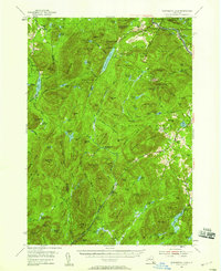
1954 Map of Thirteenth Lake
USGS Topo · Published 1958About this map
The Sacandaga River carves through a dense landscape of high summits and isolated clearings in this mid-century survey of the Adirondacks. Industry and recreation are captured in transition, notably at the Barton Mine and an Open Pit Mine near North River, where garnet extraction has long shaped the local economy. The high-elevation terrain is anchored by Gore Mtn, featuring a Lookout Tower, and the waters of Thirteenth Lake.
Find a feature on this map
120 named features on this map. Tap any name to fly to it.
Don’t see what you’re looking for? This feature index may not catch every label — zoom into the map to look around manually.
Map Details
Editions of this 1954 Thirteenth Lake Map
4 editions found

Other maps of this area

1895 · North Creek
USGS Topo · 1:62,500

1897 · North Creek
USGS Topo · 1:62,500

1897 · Schroon Lake
USGS Topo · 1:62,500

1898 · Newcomb
USGS Topo · 1:62,500

1898 · Thirteenth Lake
USGS Topo · 1:62,500

1899 · Indian Lake
USGS Topo · 1:62,500

1901 · Newcomb
USGS Topo · 1:62,500

1902 · Indian Lake
USGS Topo · 1:62,500

1903 · Luzerne
USGS Topo · 1:62,500

1903 · Blue Mountain
USGS Topo · 1:62,500