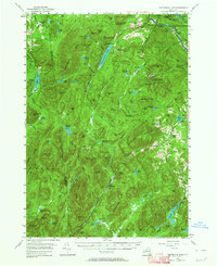
1954 Map of Thirteenth Lake
USGS Topo · Published 1964About this map
Bakers Mills and Oregon anchor the southeastern portion of this mid-century Adirondack study, where the industrial history of Warren County is clearly visible through numerous mineral operations. The local garnet industry is prominently marked by the Barton Mine and Garnet Mine, alongside a large Open Pit Mine and associated Tailings. This landscape is defined by the massive rise of Gore Mtn, featuring a Lookout Tower, and Eleventh Mountain. Drainage patterns of the Sacandaga River and Hudson River define the valley corridors, while the high country is dotted with remote waters like Siamese Ponds, Thirteenth Lake, and Chatiemac Lake. The Delaware and Hudson railroad cuts through the northeastern corner near North River, tracing the river's path through the deep mountain terrain. Small community details, such as District Sch No 7, provide a look at the social infrastructure of these high-elevation settlements during the 1950s.
Find a feature on this map
146 named features on this map. Tap any name to fly to it.
Don’t see what you’re looking for? This feature index may not catch every label — zoom into the map to look around manually.
Map Details
Editions of this 1954 Thirteenth Lake Map
4 editions found

Other maps of this area

1895 · North Creek
USGS Topo · 1:62,500

1897 · North Creek
USGS Topo · 1:62,500

1897 · Schroon Lake
USGS Topo · 1:62,500

1898 · Newcomb
USGS Topo · 1:62,500

1898 · Thirteenth Lake
USGS Topo · 1:62,500

1899 · Indian Lake
USGS Topo · 1:62,500

1901 · Newcomb
USGS Topo · 1:62,500

1902 · Indian Lake
USGS Topo · 1:62,500

1903 · Luzerne
USGS Topo · 1:62,500

1903 · Blue Mountain
USGS Topo · 1:62,500