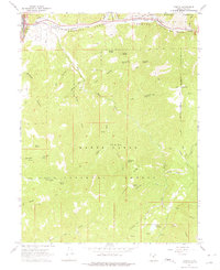
1967 Map of Thistle
USGS Topo · Published 1975About this map
The railroad junction at Thistle serves as the focal point of this 1967 survey, where the Denver & Rio Grande Western tracks diverge to follow the canyons. This vital transit node is supported by local infrastructure including the Thistle Substation and a Gaging Station situated near the confluence of Thistle Creek and Soldier Creek. The topography is dominated by the steep boundaries of the Uinta National Forest and the Manti-La Sal National Forest, which meet in this complex vertical landscape. Numerous water sources such as Jumpup Spring and Little Bear Spring are scattered across the high ridges like Coffeepot Ridge. The map documents a network of Pack Trails and Jeep Trails that provided access to these high elevations long before modern road development, while the Red Narrows along the Spanish Fork river illustrates the narrow corridors through which early pioneers and rail engineers navigated the Wasatch range.
Find a feature on this map
95 named features on this map. Tap any name to fly to it.
Don’t see what you’re looking for? This feature index may not catch every label — zoom into the map to look around manually.
Map Details
Editions of this 1967 Thistle Map
2 editions found
Other maps of this area

1885 · Salt Lake
USGS Topo · 1:250,000

1885 · Manti
USGS Topo · 1:250,000

1895 · Manti
USGS Topo · 1:250,000

1907 · Strawberry Valley
USGS Topo · 1:125,000

1909 · Strawberry Valley
USGS Topo · 1:125,000

1949 · Provo
USGS Topo · 1:62,500

1949 · Spanish Fork Peak
USGS Topo · 1:24,000

1951 · Spanish Fork Peak
USGS Topo · 1:24,000

1952 · Santaquin Peak
USGS Topo · 1:62,500

1954 · Salt Lake City
USGS Topo · 1:250,000