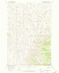
1967 Map of Thompson Creek NW
USGS Topo · Published 1971About this map
The Wolf Mountains dominate this landscape within the Crow Indian Reservation in Big Horn County. Surveyed in the late 1960s, the map reveals a rugged drainage system where Reno Creek and its tributaries, including the North Fork Reno Creek and South Fork Reno Creek, carve through the high terrain. Human activity is sparse, marked primarily by a network of Jeep Trails and occasional infrastructure like a Gravel Pit or isolated Wells. The importance of water in this semi-arid environment is evidenced by numerous named Springs and specialized watercourses like Dipping Vat Creek, which hints at the cattle ranching history of the region. The eastern portion of the map transitions into the Little Thompson Creek and Thompson Creek basins, showing a complex topography of ridges and draws.
Find a feature on this map
16 named features on this map. Tap any name to fly to it.
Don’t see what you’re looking for? This feature index may not catch every label — zoom into the map to look around manually.
Map Details
Editions of this 1967 Thompson Creek NW Map
2 editions found
Other maps of this area

1894 · Rosebud
USGS Topo · 1:125,000

1901 · Rosebud
USGS Topo · 1:125,000

1954 · Hardin
USGS Topo · 1:250,000

1957 · Hardin
USGS Topo · 1:250,000

1958 · Hardin
USGS Topo · 1:250,000

1967 · Crow Agency SE
USGS Topo · 1:24,000

1967 · Lodge Grass NE
USGS Topo · 1:24,000

1967 · Wolf Mountain Lookout
USGS Topo · 1:24,000
1967 · Jeans Fork SE
USGS Topo · 1:24,000
1967 · Thompson Creek
USGS Topo · 1:24,000